


tour du lac Issarlès

Christine Torfs
User
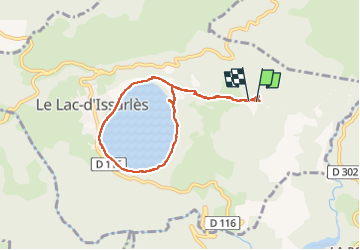

Length
7.2 km

Max alt
1229 m

Uphill gradient
300 m
Km-Effort
11.2 km

Min alt
998 m

Downhill gradient
311 m
Boucle
Yes
Creation date :
2022-08-07 12:49:57.645
Updated on :
2022-08-07 15:50:45.51
2h11
Difficulty : Very easy

FREE GPS app for hiking
 SityTrail
IGN / Geographical institutes
SityTrail Plus
The world is yours!
About
Trail Walking of 7.2 km to be discovered at Auvergne-Rhône-Alpes, Ardèche, Le Lac-d'Issarlès. This trail is proposed by Christine Torfs.
Description
belle balade à partir du gîte
Positioning
Country:
France
Region :
Auvergne-Rhône-Alpes
Department/Province :
Ardèche
Municipality :
Le Lac-d'Issarlès
Location:
Unknown
Start:(Dec)
Start:(UTM)
586220 ; 4963641 (31T) N.
Comments